
Is My Property in a Montreal Flood Zone?
|
Check whether your Montreal-area property is located within a mapped flood risk zone using official public data.
How Our Montreal Flood Risk Check Works
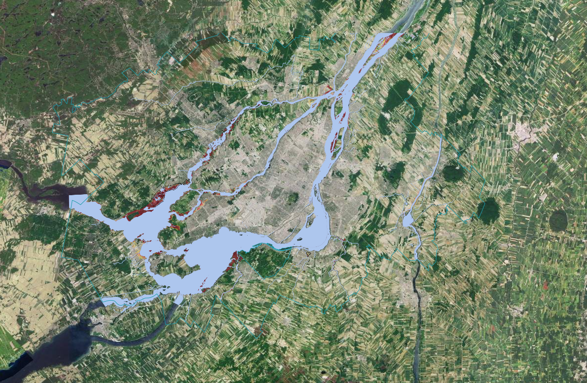
Flood risk maps are based on historical water levels, river modeling, and recurrence intervals published by provincial and municipal authorities.
By matching your property address against publicly available floodplain mapping data, we determine whether it falls within a designated flood risk zone.
For official confirmation, insurance underwriting, or transaction disclosure, municipal verification or professional review may be required.
This instant screening provides geographic flood exposure awareness — but it does not replace official municipal confirmation.
How Flood Zones Are Determined in Montreal
Flood zones in the Montreal region are defined using recurrence interval mapping such as 0–20 year and 20–100 year floodplain classifications published by provincial authorities and the City of Montreal.
These designations consider factors such as:
- Proximity to the St. Lawrence River and Rivière des Prairies
- Historical flood events (including 2017 and 2019)
- Elevation and topography
- Hydrological modeling and water level simulations
- Municipal and provincial floodplain mapping updates
- Official land-use and environmental planning data
An automated flood risk screening identifies whether your property is located within a mapped floodplain boundary.
However, insurance eligibility, reconstruction rules, and transaction disclosure requirements depend on official municipal confirmation and current regulations.
Automated Flood Screening vs. Official Verification
Understand the difference between a location-based flood check and official municipal confirmation.
| Instant Flood Risk Check | Official Municipal Confirmation | |
|---|---|---|
| Uses public floodplain mapping data | ||
| Identifies 0–20 year flood zones | ||
| Identifies 20–100 year flood zones | ||
| Property-specific file review | — | |
| Recognized for legal documentation | — | |
| Insurance underwriting confirmation | — | |
| Instant online result | — | |
| Definitive regulatory determination | — |
Frequently Asked Questions
Everything you need to know about hiring the best realtors in Montreal
Take their word for it
First-time home buyer
A great resource for our first home buying experience. With great patience and knowledge about the needs and procedures of Quebec real estate.
First-time home buyer
Very knowledgeable about Montreal real estate. Made buying my first home easy and helped me avoid houses with hidden issues. Always explained potential problems clearly.

Home buyer
More than just an agent — a true ally! Knowledgeable, honest, and helps you avoid traps disguised as "good deals." Thanks to this guidance, we found an INCREDIBLE home and felt confident every step of the way.
Check Your Montreal Flood Risk
Get your free instant flood zone screening — and understand your property's exposure.